Leonce Viator and his nephew Timmy Dore tied their fishing boat to a tree and ran ashore. Behind them, Lake Peigneur was disappearing into the ground. When Viator looked back, the tree was being carried into the swirling water too.
Viator described that escape to United Press International after the November 20, 1980, disaster in southern Louisiana. Barges and trees had been drawn toward an opening in the lake. A familiar place to fish had become somewhere they needed to leave immediately.
The danger extended beneath them. Fifty-two people were working underground in Diamond Crystal Salt Company’s Jefferson Island mine. Water from the lake was entering the workings. They all got out, but the rescue clock was much shorter than the scale of the destruction might suggest: the federal mine-safety agency later reported that the evacuation took less than an hour after an electrician discovered the inflow.
Two industries, one stretch of ground
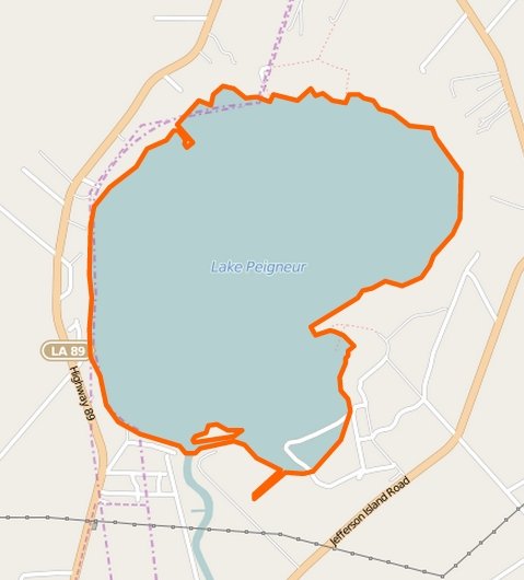
Lake Peigneur lies beside Jefferson Island, one of the salt domes known as Louisiana’s “five islands.” The name can suggest an ordinary island surrounded by water. Here it refers to elevated ground associated with a much larger underground salt structure.
That structure supported different businesses. Salt was mined below the area; oil exploration took place from the lake. As the Louisiana Endowment for the Humanities’ 64 Parishes explains, Texaco held a lease covering the lake and contracted Wilson Brothers to drill from a floating platform. Nearby, Live Oak Gardens had developed into a horticultural attraction. Fishermen, drilling crews, miners and nursery employees shared the landscape while working in very different parts of it.
On November 20, the drilling crew encountered a problem with the well. A technical report prepared for the Texas Water Development Board, drawing on geologist Whitney Autin’s study, describes a stuck drill bit and lost drilling mud. Attempts to free the equipment failed. Then the platform tilted.
The crew abandoned it. The university library’s account of the disaster describes the loss of the rig’s 150-foot derrick as the lake began draining. Getting off the platform did not stop the collapse. It put the workers out of the path of equipment they could no longer save.
The escape below the lake
For the people underground, the first essential discovery was that water was coming in. The Mine Safety and Health Administration’s annual report for fiscal year 1981 identifies a mine electrician as the person who detected the inflow. It records 52 people underground and their safe evacuation in less than an hour.
MSHA specifically credited training in emergency evacuation procedures. Its account does not present survival as luck alone. Workers had procedures to act on when a problem underground became an immediate threat. The agency reported no injuries in the mine flood, despite the extensive property damage.
The shore stopped being safe
At Live Oak Gardens, nursery operator Mike Richard was also receiving warnings. In a later interview with WVUE’s Heart of Louisiana, he recalled repeated tremors and a visit from a mine superintendent who advised evacuating employees.
Richard filmed the disaster with a Super-8 camera from the balcony of a lakefront house. The film preserved a view of the spreading collapse. The house from which he filmed was itself subsequently lost to the water, along with greenhouses and surrounding land.
That sequence explains why merely reaching the bank was not the same as reaching permanent safety. The lake’s edge was changing. Trees and buildings stood on land that could give way as the opening grew. Viator and Dore’s abandoned boat had been tied to something solid; the tree’s disappearance showed how quickly that judgment could become obsolete.
The University of Louisiana at Lafayette Libraries’ retrospective records eleven barges going down and nine later resurfacing. Its archival collection includes photographs of the disaster. These were substantial vessels moving into an opening beneath a lake, not objects washed downstream by an ordinary river flood.
A canal ran backward
Water did not only leave Lake Peigneur. It began arriving from the opposite direction along the Delcambre Canal, which normally carried water away from the lake toward the Gulf. The drop into the emptied basin produced a temporary waterfall. As water continued entering the underground space and basin, the lake began filling again.
By November 21, UPI was reporting that refilling was underway. The university retrospective describes the process taking about two days. The water returned to a place whose shoreline, industrial workings and buildings had been profoundly altered. Refilling the basin could not restore the mine or put the lost property back on dry ground.
What remains uncertain?
The familiar explanation is that an oil drill punctured the salt mine and the lake drained through the breach. The Texas Water Development Board report discusses a possible inadvertent breach into a mined opening. That qualification matters: describing the connection between the lake and mine is different from proving every step that created it.
Claims that a particular wrong map or coordinate mistake definitively explains the event go beyond the evidence used here. So does a clean transformation from an entirely freshwater lake to a saltwater one: contemporary UPI reporting already described Peigneur as brackish. Exact depths also vary among accounts. The disaster does not need a disputed measurement to remain extraordinary.
The clearest outcome is less complicated. A lake entered a working mine, a shoreline collapsed, and everyone escaped. The federal record preserves the number behind that last statement: 52 people underground, safely evacuated. Beside the photographs of disappearing machinery, that is the fact worth holding onto.
Timeline of Events
- November 20, 1980: A drilling emergency and an inflow into the Jefferson Island salt mine develop at Lake Peigneur. Crews abandon the rig; all 52 people underground evacuate safely.
- Later that day: The collapse consumes equipment and shoreline property. The Delcambre Canal reverses direction.
- November 21 and the following period: Reporting describes the lake refilling; the university retrospective puts the refill at about two days.
- Fiscal year 1981 report: MSHA documents the successful evacuation and credits emergency training.
Frequently Asked Questions
Did anyone die in the Lake Peigneur disaster?
No deaths were reported. MSHA records all 52 people underground escaping safely; contemporary reporting also describes the drilling crew and fishermen getting out.
Did the lake disappear permanently?
No. It drained into the mine and then refilled, with water coming back through the reversed Delcambre Canal. The surrounding damage remained.
Was a wrong drilling map conclusively responsible?
The technical report describes a possible inadvertent breach, without establishing a specific mapping mistake as its cause.
Related Stories
For another account in which procedures and evacuation decisions mattered under water, read the USS Squalus rescue. For a very different industrial failure that spread beyond its workplace, see the London Beer Flood of 1814.
Sources & References
- United Press International, November 21, 1980 — contemporary reporting, including Viator’s account and the lake’s refilling.
- U.S. Department of Labor, MSHA annual report for fiscal year 1981, printed page 55 — the number evacuated, elapsed time and role of training.
- Texas Water Development Board contracted technical report, PDF page 137 — discussion of the Peigneur drilling sequence and possible breach, drawing on Autin’s research.
- WVUE, “Heart of Louisiana: Lake Peigneur”, published November 24, 2010, updated January 11, 2013 — survivor interviews and Richard’s filming.
- University of Louisiana at Lafayette Libraries, Lake Peigneur retrospective, November 18, 2022 — the rig, barges, refilling and archival photographs.
- 64 Parishes, “Lake Peigneur Drilling Accident”, July 28, 2023 — geographical and industrial background.
Featured image: 2015 location map of Lake Peigneur, not a reconstruction of the 1980 shoreline. © OpenStreetMap contributors (map data under the Open Database License), via Wikimedia Commons; map image licensed CC BY 2.5. Source file unchanged.